This Excel template makes it easy to create geographic heat map at the state level for 50 states of U.S.
REQUIREMENTS
You need a copy of Microsoft Excel to open this file. The product has been tested in
FEATURES
BUY
You can purchase the template by using the 'Add to Cart' button below and then choosing Checkout. You will be redirected by ejunkie.com to PayPal where you can use your credit card or PayPal account to purchase. You can download the Excel file instantly after payment. An e-mail will also be sent to your e-mail address with a link that you can use to download later. You will also receive all future upgrades of this product to your e-mail for free.
US$10


HOW TO USE THE TEMPLATE
The video below demonstrates the use of the template.
PRINTING
In Excel, when you try to print, the print area in the file is already pre-set to print only the map.
If you would like to print the entire sheet, click 'Ignore print area' when you print (as shown in the image below). That would print the entire sheet.
SAVING AS PDF
Similarly, you can save as PDF. By default, only the map will be saved in the PDF.
If you would like the entire sheet to be saved in PDF, choose Options and check the 'Ignore Print Area' option.
COPY/PASTE
You can also copy the image by righ clicking on the map and choosing 'Copy'. You can then paste in other applications such as PowerPoint and Word.
CHANGE COLOURS
If you would like to change the gradient colours used, please follow the steps outlined below. Please make sure that the legend (under the heat map image) is updated when you change colours.
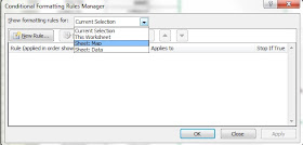
1. Open the Conditional formatting menu and choose 'Manage Rules'.
2. Choose the sheet: Map
3. Select the Gradient Colour Scale rule and then click Edit Rule.
4. Change the colours (for minimum, midpoint and maximum) as needed.
If you are familiar with Excel, you can use other conditional formatting rules too.
If there are any questions, please e-mail indzara at gmail and mention 'U.S. Geographic Heat Map'.
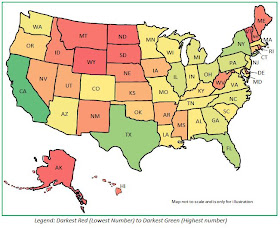 |
| U.S. Geographic State Heat Map Excel Template |
REQUIREMENTS
You need a copy of Microsoft Excel to open this file. The product has been tested in
- Microsoft Excel 2007, 2010 and 2013 for Windows
- Microsoft Excel 2011 for Mac
FEATURES
- Instant Heat maps in Excel
- Print or Save as PDF
- Copy Heat map and paste it in other applications such as PowerPoint, Word
- Accepts State full names as well as standard abbreviations
- Can enter up to 5 numeric fields at a time and choose any one to display
- By default creates gradient scale heat map, but can also create other types of conditional formatting that Excel allows
- Works in Excel for Windows (2007, 2010 and 2013) and Excel for Mac (2011)
BUY
You can purchase the template by using the 'Add to Cart' button below and then choosing Checkout. You will be redirected by ejunkie.com to PayPal where you can use your credit card or PayPal account to purchase. You can download the Excel file instantly after payment. An e-mail will also be sent to your e-mail address with a link that you can use to download later. You will also receive all future upgrades of this product to your e-mail for free.
US$10
HOW TO USE THE TEMPLATE
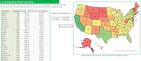 |
| U.S. Geographic State Heat Map Excel Template |
- Copy and paste the data from other sources into the template. Or you can type the data directly.
- Choose the field that has the state information
- Choose the field that has the data you would like to display on map
- View/Print/Export the Heat map. Or you can copy the image and paste in other applications as needed.
The video below demonstrates the use of the template.
PRINTING
In Excel, when you try to print, the print area in the file is already pre-set to print only the map.
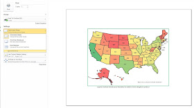 |
| U.S. Geographic State Heat Map (Print map) |
If you would like to print the entire sheet, click 'Ignore print area' when you print (as shown in the image below). That would print the entire sheet.
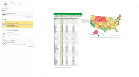 |
| U.S. Geographic State Heat Map (Print map with data) |
SAVING AS PDF
Similarly, you can save as PDF. By default, only the map will be saved in the PDF.
 |
| U.S. Geographic State Heat Map Excel Template (PDF Map) |
 |
| U.S. Geographic State Heat Map Excel Template (PDF Map with Data) |
You can also copy the image by righ clicking on the map and choosing 'Copy'. You can then paste in other applications such as PowerPoint and Word.
CHANGE COLOURS
If you would like to change the gradient colours used, please follow the steps outlined below. Please make sure that the legend (under the heat map image) is updated when you change colours.
1. Open the Conditional formatting menu and choose 'Manage Rules'.
2. Choose the sheet: Map
3. Select the Gradient Colour Scale rule and then click Edit Rule.
4. Change the colours (for minimum, midpoint and maximum) as needed.
If you are familiar with Excel, you can use other conditional formatting rules too.
If there are any questions, please e-mail indzara at gmail and mention 'U.S. Geographic Heat Map'.



No comments:
Post a Comment